
Map of Japan
Izu Islands
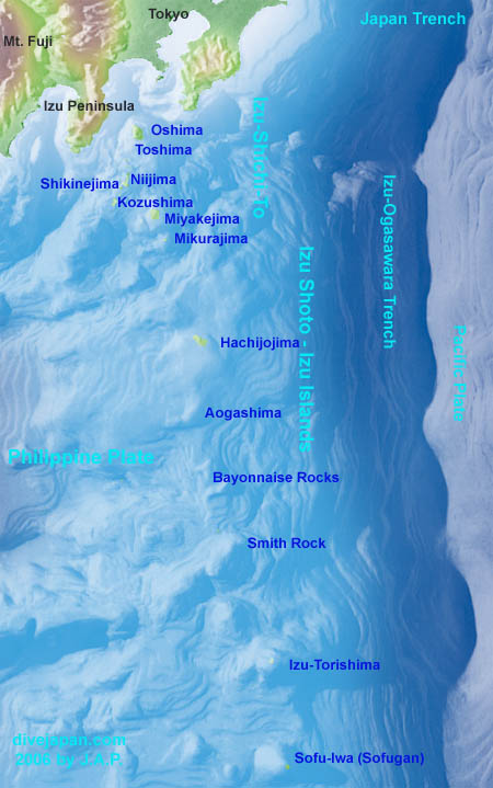
Izu Shoto
![]() Each Island name links to PDF file including photos, relief image map and discription of the island
Each Island name links to PDF file including photos, relief image map and discription of the island
at National Catalogue of The Active Volcanoes in Japan (4th Edition) - English Version. For example;
Miyakejima (PDF 9.252 KB)
![]() 海域火山データベース You can click a volcaoe name on the map and you will find information including underwater geography map, bird view map and photographs.
海域火山データベース You can click a volcaoe name on the map and you will find information including underwater geography map, bird view map and photographs.
This is at Hydrographic and Oceanographic Department (海洋情報部) at Japan Coast Guard (海上保安庁). For example;
This is at Japanese site. (not found at their English version site yet.)
![]() Japanese Volcanoes at Global Volcanism Program at Simisoniun Institution National Museum of Natural History
Japanese Volcanoes at Global Volcanism Program at Simisoniun Institution National Museum of Natural History
Plate Tectonics Theory
Izu Islands are volcanic islands on subduction zone on the margin of Philippine plate that borders Pacific plate. Here are some of links about trenches, plates and plate tectonic theory.
![]() Tectonic plates in the world (simple map)
Tectonic plates in the world (simple map)
at This Dynamic Earth at USCG Geographical Survey
![]() The Rocky History of an Idea and Mechanism
The Rocky History of an Idea and Mechanism
at Geology: Plate Tectonics at UCMP University of California Museum of Paleontology
![]() If you feel that plate tectonics theory does not explain the process fully, here's a link I came across. Questions raised might interest you.
If you feel that plate tectonics theory does not explain the process fully, here's a link I came across. Questions raised might interest you.
Oceanic Crust at Shock Dynamics
Izu Island Page
Visit for scuba diving and other information.